How water is managed in the Fitzroy, Boyne River and Calliope River water plan areas now
The current water plans for the Fitzroy Basin, Boyne River Basin and Calliope River Basin set the rules for allocating and using:
- water in watercourses (river, streams, creeks etc), lakes and springs
- overland flow water (only regulated within the Fitzroy Basin and Calliope River Basin water plan areas)
- groundwater (only regulated within the Fitzroy Basin water plan area).
A total of 1,084,276ML of this water is currently allocated through entitlements across the 3 water plans.
Water taken from watercourses, lakes and springs is managed in the coastal areas of Styx, Waterpark and Shoalwater basins through the Water Act 2000. Groundwater in the Farnborough underground management area is managed under the Water Regulation 2016.
This table shows what is managed under the existing 3 water plans and in the coastal areas not currently in a water plan.
| What can be managed | Fitzroy | Boyne | Calliope | Coastal |
|---|---|---|---|---|
| Watercourse water | Yes | Yes | Yes | Yes |
| Overland flow water | Yes | No | Yes | No |
| Groundwater | Yes | No | No | Yes |
| Unallocated water | Yes | Yes | Yes | No |
| Water trading | Yes | Yes | No | No |
| Water allocations | Yes | Yes | No | No |
| Water licences | Yes | Yes | Yes | Yes |
| Resource operations licence (ROL) for water supply schemes | Yes (6) | Yes (1) | No | No |
| Distribution operations licence (DOL) | Yes (2) | No | No | No |
If we develop a Central Queensland (CQ) water plan, we will use science and consultation to consider aligning these management arrangements across the region. This would not necessarily mean major changes to how water is currently managed; it would just bring the rules neatly into the water planning framework.
Water in watercourses, lakes and springs
When people or companies take water directly from the watercourses, lakes or springs, we call it unsupplemented water use. People in this CQ area currently take unsupplemented surface water through either water licences or water allocations.
There are several water supply schemes (WSS) that supply supplemented water from dams and weirs for various purposes in the area which include:
- Awoonga WSS owned and operated by Gladstone Area Water Board
- Dawson Valley WSS owned and operated by Sunwater
- Callide Valley WSS owned and operated by Sunwater
- Theodore Channel scheme (Dawson Valley WSS) owned and operated by Theodore Water
- Nogoa Mackenzie WSS owned and operated by Sunwater
- Fitzroy Barrage WSS owned and operated by Rockhampton Regional Council
- Lower Fitzroy WSS owned and operated by Sunwater
- Rookwood Weir WSS owned and operated by Sunwater
- Emerald Channel scheme (Nogoa Mackenzie WSS) owned and operated by Fairbairn Irrigation Network Pty Ltd.
Overland flow
Overland flow is water that runs across the land after rainfall, either before it enters a watercourse, after it leaves a watercourse as floodwater, or after it rises to the surface naturally from underground.
People capture overland flow using pumps, channels or drains and store this water in tanks or dams. In water plans, we call these types of things ‘works’.
Under the Boyne River Basin water plan, overland flow capture is currently unregulated which means people do not need a water entitlement to take it.
The water plans for the Fitzroy and the Calliope River basins allow people to take overland flow without a water entitlement, if the water is being taken:
- for stock and domestic use
- to satisfy the requirements of an authority under the Environmental Protection Act 1994, for example, to manage contaminated agricultural runoff
- for any purpose if a new storage is no more than
- 5ML in the Calliope River Basin
- 5ML for overland flow that is downstream of the Fitzroy Barrage subcatchment area (shown in the map below)
- 50ML for other parts of the Fitzroy Basin water plan area.
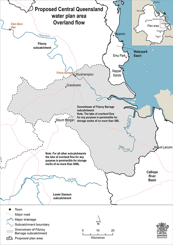
Map showing the area downstream of the Fitzroy Barrage subcatchment.
As part of this review, we will conduct a scientific assessment to identify overland flow storages across the whole CQ area. We will use this information, along with public feedback, to determine the most appropriate storage limits or other regulations for the taking of overland flow for the whole CQ region.
Groundwater
Groundwater (also called underground water) is the water beneath the earth’s surface that occurs in pore spaces and fractures of rock formations called aquifers.
Under the Fitzroy Basin water plan, groundwater is managed by either preventing new development to protect existing water users, or by implementing management rules in high use areas to ensure water is accessed equitably. Groundwater is particularly important to sustaining irrigation in the Callide Valley and Don and Dee groundwater management areas.
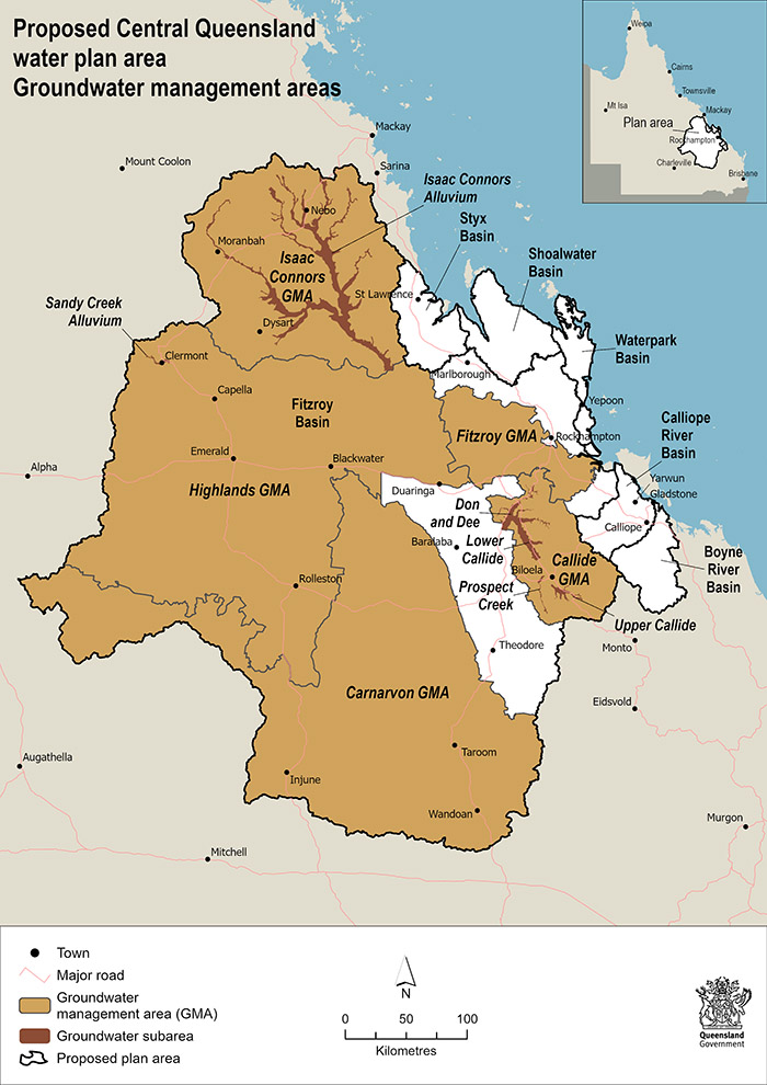
Map showing the groundwater management areas within the proposed Central Queensland water plan area.
There are no groundwater management areas in the Boyne River Basin or Calliope River Basin water plan areas.
If you are outside of a groundwater management area, you may still drill a bore to access water in addition to constructing a bore to supply stock and domestic water.
The Farnborough underground water area within the Waterpark Basin is currently regulated under the Water Regulation 2016. We’re proposing to bring these existing rules into the CQ water plan and protocol.
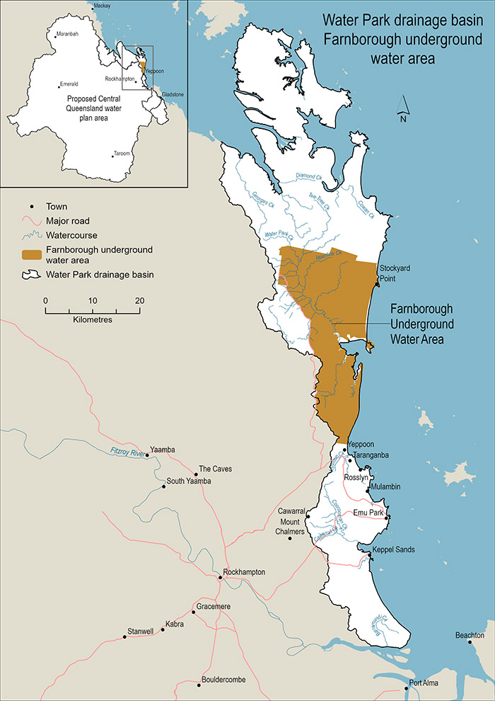
Map showing where Farnborough underground water area is located.
As we review these water plans, we will use public feedback and scientific assessments to find the best way to manage groundwater use across the CQ region.
Also consider…
- View the Fitzroy Basin:
- View the Boyne River Basin:
- View the Calliope River Basin: