Preliminary public consultation notice – Replacement of the Water Resource (Whitsunday) Plan 2010 – s44 of the Water Act 2000
1. Proposal to replace the Water Resource (Whitsunday) Plan 2010 and include coastal areas of the Don, Proserpine and O’Connell basins
Notice is given under section 44 of the Water Act 2000 (the Act) that the Minister for Local Government and Water and Minister for Fire, Disaster Recovery and Volunteers proposes to replace the Water Resource (Whitsunday) Plan 2010 (the water plan).
2. Water to which the water plan will apply
It is proposed that the new plan will continue to apply to the following water as described in the original water plan area, including:
- water in watercourses, lakes and springs (surface water)
- overland flow water
- underground water.
It is proposed to extend to the Don, Proserpine and O’Connell basins (coastal areas) within the proposed extended boundary and to apply to the following water:
- water in watercourses, lakes and springs (surface water)
- underground water in the Bowen underground water area and Dryander underground water area.
The water plan and proposed extended boundary is shown in Figure 1.
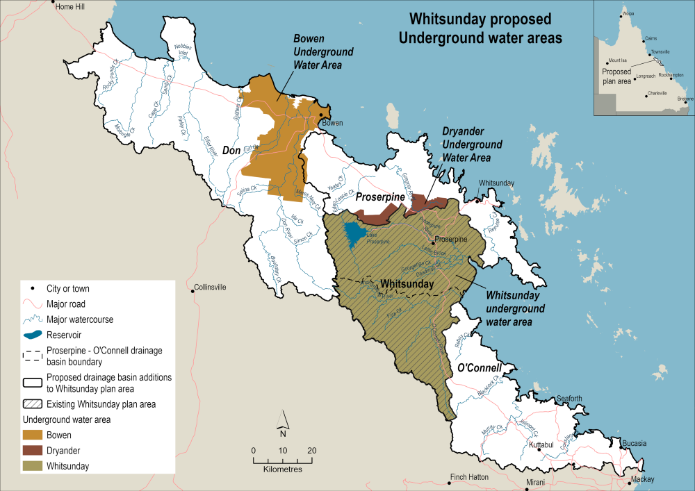
Figure 1: Map of the proposed Whitsunday water plan area
3. Reason for preparing the replacement water plan
The water plan is due to expire 1 December 2025 and it is proposed to be replaced with a new water plan to continue to advance the sustainable management of water resources in the water plan area. Assessments indicate that the implementation of the water plan has been effective in achieving most of its outcomes and advancing the sustainable management of water. A review of the water plan will consider an increase in water demand, as well as the emerging challenges identified in the Minister’s performance assessment report in Appendix A below.
The review will be conducted consistent with the requirements of the Act with a particular focus on the Queensland Government’s election commitment to enhance water security for Queensland communities, ensuring sustainable growth and resilience in water supply. The review will also be a part of the delivery of the commitment to review each of the 23 Queensland regional water plans in the next four years to determine if unallocated water can be provided to boost agricultural productivity.
To ensure the water plan continues to advance the sustainable management of water resources, the following matters need to be considered:
- making water available to secure supply and foster economic growth, including identifying options to meet growing demand for new irrigated agriculture (in line with the government’s plan to grow agricultural production by $30 billion by 2030), urban water and critical minerals while balancing associated impacts on other water interests and values
- any future water requirements for anticipated further population growth in the plan area
- emergent water security needs for the plan area (including securing water supplies for First Nations communities) with a focus on affordability
- water entitlements, including the potential for water licences to be converted to water allocations
- water trading, including identifying any barriers to accessing the existing trading framework to improve water resource utilisation and support economic development
- water management arrangements for surface water, underground water and overland flow management
- incorporating best-available science on water availability and the water needs for the environment
- inclusion of the Don Basin and areas of the Proserpine and O’Connell basins into the new water plan
- requirements under the Human Rights Act 2019.
In preparing a replacement plan, I propose to address these issues. Key documents that implement the water plan will also be developed or amended, as necessary.
4. Proposed arrangements for consultation
Submissions are now being sought. I encourage anyone with an interest in the Whitsunday water plan area, or the additional coastal areas to the north and south, to put forward their thoughts on water resource management in the proposed replacement water plan area through a submission.
Submissions received and engagement with key stakeholders including water users, water supply scheme operators, First Nations Peoples and other interest groups will inform the development of the draft replacement plan.
There will be further opportunity for consultation through a public submissions process and meetings with key stakeholders following the release of the draft replacement water plan.
5. Enquiries and submission process
To make a submission on water planning issues within the existing Whitsunday water plan area and the proposed new plan area please contact the department:
- email NorthWPS@dlgwv.qld.gov.au
- phone 1800 822 100
- post to
Department of Local Government, Water and Volunteers
Water Services North Region
Attention: Manager Water Planning
PO Box 591
AYR QLD 4807
Preliminary consultation submissions will close on 31 October 2025.
This notice is dated 30 June 2025.
The Hon. Ann Leahy MP
Minister for Local Government and Water and
Minister for Fire, Disaster Recovery and Volunteers
Ingrid Fomiatti Minnesma
Executive Director Northern Region (as the Chief Executive’s delegate)
Appendix A – Minister's performance assessment report
1. Minister's foreword
I am pleased to publish the performance report for the Water Resource (Whitsunday) Plan 2010 (the water plan). This performance report assesses the effectiveness of the water plan and its implementation since 2010.
My department has been monitoring and developing this water plan using best practice technical assessments.
Industry, tourism and agriculture, including sugarcane and grazing, are primary economic drivers for the Whitsunday area; therefore, I recognise the need to balance the consumptive use for these industries and other economic uses, with non-consumptive uses, including those that sustain tourism, recreation, and cultural values.
This report confirms that the water plan and its implementation continue to be effective in advancing the sustainable management of water resources in the Whitsunday water plan area. The water plan will be reviewed, with a draft replacement plan currently being developed.
Residents in the Whitsunday water plan area can be assured that their region's water resources are being managed responsibly and sustainably. I encourage anyone interested in water management in the Whitsunday water plan area to read this report.
Hon. Ann Leahy MP
Minister for Local Government and Water and
Minister for Fire, Disaster Recovery and Volunteers
2. Purpose of report
The Water Act 2000 (the Act) requires the Minister to prepare reports for each water plan to ensure the implementation and effectiveness is regularly assessed as part of an adaptive management/water planning cycle. This cycle involves water plan development, implementation, monitoring, reporting and reviewing.
The Water Regulation 2016 (the Regulation) requires these reports to be prepared at least every 5 years and address the following matters:
- if the water plan is advancing the sustainable management of Queensland’s water resources
- the effectiveness of implementation in achieving the water plan’s outcomes
- information on water usage and authorisations in the water plan area, including water entitlements and water taken or interfered with under statutory authorisations
- a summary of the findings of research and monitoring for the water plan
- any identified risks to achieving the water plan’s outcomes
- what amendments, if any, have been made to the water plan since its commencement
- any noncompliance under a water entitlement or other authorisation in the water plan area.
This report provides an overview of the above matters and evaluates the implementation of the water plan to date, with an emphasis on progress since the previous report was prepared in 2019.
A risk assessment completed in April 2025 identified potential risks to the plan’s outcomes from its implementation. The risk assessment approach used was consistent with the ISO 31000:2018 Risk Management Guideline. This approach ensures a consistent, repeatable and defensible consideration of risks and that outcomes of the assessment are documented for future reference.
Note: All data contained in this report is current as of May 2025.
3. Plan area
The water plan area is approximately 2050 km2 and can be found North of Mackay, Central Queensland. It supports the water needs of several urban and regional centres including Proserpine, Airlie Beach, Bowen, Bloomsbury and Midge Point. The plan area includes 1 water supply scheme (WSS)–the Proserpine River WSS with 2 sub schemes, the Kelsey Creek and Six Mile Creek schemes–providing water for crop farms and for people living in Proserpine and surrounds. Infrastructure for storing bulk amounts of water is via Peter Faust Dam.
Figure 2 on the following page shows the key features of the water plan area including details about unallocated water reserves and water entitlements.
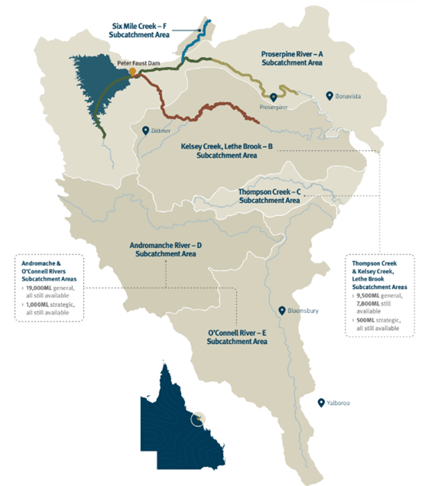
Figure 2: Map showing Whitsunday water plan features
4. How the plan advances the sustainable management of Queensland's water resources
The outcomes and strategies in the Whitsunday water plan are designed to promote sustainable management and efficient use of water resources. The assessment in the subsequent sections of this report, indicate that the implementation of the water plan has been effective in achieving most of the plan’s outcomes and advancing the sustainable management of Queensland’s water resources in the plan area.
However, a review and replacement of the water plan is necessary to respond to increasing water demand, as well as the emerging challenges identified in the previous performance assessment report. A review and replacement of the water plan will allow the department to respond to the needs of water users, the environment and cultural values. Underpinned by science and community consultation, this review would also consider climate variability impacts and promoting efficient water use and allocation.
5. How well the plan is being implemented and identification of potential risks
Since the water plan started in 2010, the department has monitored its implementation to ensure the outcomes are being achieved. In April 2025, we completed a risk assessment to identify any potential risks to the water plan’s outcomes that could emerge within the lifetime of the water plan. By analysing changes in the water plan area over and beyond the life of the plan, we identified future water demands, any potential risks and emerging matters. We used data and expert opinion to rank the likelihood and consequence of risk from a standardised list of threats and documented the risk level and rationale for this ranking.
Of the 19 water plan outcomes assessed, seven were ranked as a medium risk, and three were ranked as high risk. The remaining 9 were ranked as low risk.
Outcomes ranked as medium risk were in relation to:
- protecting the probability to take water under a water allocation
- ensuring water and flow regimes are available to support natural ecosystem processes
- providing continued capability of river connectivity and maintaining flood flows to fresh water, estuarine and marine environments
- maintain connectivity between surface water and underground water.
Outcomes ranked as high risk were in relation to:
- maintaining and minimising changes to the natural variability of flows
- minimising adverse impacts on ecology and morphology of surface water in the Proserpine River Water Supply Scheme.
Outcomes that are assessed as either a medium or high risk, could impact on the ability of water plan to sustainably manage water resources. The following issues and risks were identified for consideration through the risk assessment performed in April 2025:
- the implementation of the plan being incomplete, specifically in subcatchments in D and E
- new knowledge is not reflected in the plan and needs to be updated with the best available science (old hydrological models, climate change not considered, old plan strategies)
- insufficient knowledge of the resource and water requirements to measure, track, analyse and manage trends. Unknown level of true demand for water in the water plan area
- the need to provide additional water for agricultural development either through unallocated water (UAW) releases or via trading
- climate impacts on water availability are increasing or expected to increase demand for water resources
- insufficient knowledge of cultural values and First Nations peoples aspirations in the water plan area
- rising underground water in the Kelsey Creek subcatchment
- increase in surface water interception (e.g., overland flow)
- contamination of underground water supply from threats such as PFAS (Per and poly-fluoroalkyl substances) and rising salinity level in underground water
- ROL/DOL holder licences have minimal strategies for environmental management.
- increase in take of underground water and surface water entitlements beyond permitted levels
- take of hydrologically connected surface water and underground water resources impacting water availability
- water trading framework is restricted to the Proserpine River water supply scheme and associated distribution areas.
- potential impacts from the Dittmer Gold mine.
Given the number of issues and risks identified through the risk assessment, a review an update of the water plan, including the outcomes set out in the plan, would be timely.
6. Water use and authorisations
Water users in this water plan area are authorised to take water under a water entitlement (e.g. water allocation or water licence) or under a statutory authorisation through the Act. An entitlement is not needed for low-risk activities such as stock and domestic, or prescribed activities such as filling spray units, washing produce and washing down equipment, plant, or vehicles to prevent the spread of weed seeds. UAW is reserved and can be made available for future use with consideration to protecting existing entitlements and flows for cultural values and aquatic ecosystems.
6.1. Water entitlements
Water entitlements in the water plan area are spread over 6 subcatchments and consist of the following, as outlined in Table 1:
- water allocations to take supplemented water
- water licences to take unsupplemented surface water
- water licences to take underground water.
Table 1: Water entitlements
| Water classification | Volume - total number | Volume - total nominal volume (ML) | Area based - total number | Area based - nominal volume (Ha) | Other - total number |
|---|---|---|---|---|---|
| Surface water allocations | 183 | 62,876 | 0 | 0 | 183 |
| Surface water licences | 47 | 7,377 | 78 | 2,137 | 125 |
| Ground water licences | 126 | 17,658 | 0 | 0 | 126 |
6.2. Water use
In accordance with section 107 of the Water Regulation, all water entitlements in the water plan area, other than licences for stock or domestic purposes, or licences in the Adromache and O’Connell subcatchments (D and E respectively) are measured (metered). This means a significant portion of the take of water in the water plan remains unmeasured.
Trends in water use data from entitlements that are metered are dominated by seasonal conditions and do not show a clear increase in utilisation. However, there is interest in new water entitlements for new or expanded agricultural use which indicates that given the right seasonal availability, water use is likely to increase over time.
The department manages unsupplemented water licences across the 3 of the 6 subcatchments and in the Whitsunday groundwater water management area. Water licences are not subject to announce entitlements or water sharing rules in the plan area.
The Proserpine WSS delivers supplemented surface water entitlements within 3 subcatchment areas of the water plan. Sunwater Limited is the resource operations licence (ROL) holder for the WSS and distributes water from Peter Faust dam to the Proserpine River water allocation holders, and two distribution operation licence (DOL) holders, Six Mile Creek Irrigators Co-operative Limited and Kelsey Creek Water Co-operative Limited.
Visit the Sunwater website for further information regarding announced allocations and trading provisions (temporary and permanent) for supplemented water allocations, and to view the ranges of announced allocations for each of the zones within the WSS. High priority A and medium priority A1 water allocations are located on the Proserpine River and distributed by Sunwater Limited under the ROL. The medium priority A2 water allocations are distributed by the Six Mile Creek Irrigator Co-operative Limited. Medium priority A3 water allocations are distributed by the Kelsey Creek Water Co-operative Limited via Lethe Brook, Kelsey Creek and associated infrastructure. Water use from the supplemented water entitlements in the plan area (Proserpine WSS) is provided in Table 2 below.
Table 2: Water use in the Proserpine River WSS
| Water year | Authorised volume under metered entitlements (ML) | Volume taken (ML) | Water taken as a percentage of authorised entitlement (%) |
|---|---|---|---|
| 2019-20 | 62, 876 | 27, 756 | 44 |
| 2020-21 | 62, 876 | 25, 801 | 41 |
| 2021-22 | 62, 876 | 18, 991 | 30 |
| 2022-23 | 62, 876 | 6, 941 | 11 |
| 2023-24 | 62, 876 | 16, 742 | 27 |
6.3. Water trading/transfers
The water management protocol (PDF, 237KB) sets out rules for water licence dealings. There is no trading (temporarily or permanently) available for water licences in the water plan area.
Water allocation trading in the plan area occurs as supplemented surface water within the Proserpine River WSS.
6.4. Entitlements granted from the unallocated water (UAW) reserve
The water plan provides for 19,000ML of general reserve UAW in the Andromache and O’Connell subcatchment areas, and 9,500ML (7,800ML remaining) of general reserve UAW in the Thompson Creek, Kelsey Creek and Lethe Brook subcatchment areas to meet demands for additional water across the water plan area. In addition, there is 1,000ML in the Andromache and O’Connell and 500ML in the Thompson Creek, Kelsey Creek and Lethe Brook subcatchment areas set aside as strategic reserve UAW. The details of the UAW reserve are provided in Section 3 – Plan area.
During the reporting period, there have been no releases of UAW in the water plan area.
6.5. Water taken or interfered with under statutory authorisations
The Act (sections 93–103) authorises people to take or interfere with water without an entitlement for certain purposes such as stock or domestic take and other low risk activities. The volume of water taken under statutory authorisations (basic rights) is not required to be measured. This makes an accurate quantitative assessment difficult. However, by identifying broad trends in consumptive water use behaviour as well as relevant water flow patterns, it is possible for us to understand if there are any risks to existing water users’ rights or the environment.
The department has assessed the risk to water users and the environment from the use of water under statutory authorisations. The assessment indicates that there is no identified increase in take of water under statutory authorisations in the water plan area.
7. Research and monitoring findings
The water planning framework is supported by water monitoring activities, including water quality of surface freshwater and underground water systems across Queensland. Together with targeted ecological monitoring for water plans, this information is vital for continued improvement of water planning.
Through our Environmental Flows Assessment Program (EFAP), we undertake ecological monitoring to assess the effectiveness of each water plan in achieving its stated ecological outcomes. Ecological assets with critical links to flow that represent the plans ecological outcomes, and the various aspects of the flow regime, are selected as indicators of the broader ecosystem for monitoring. Information collected by EFAP is used by the Department of Environment, Tourism, Science and Innovation (DETSI) to assess the effectiveness of the plan in achieving ecological outcomes, using a risk assessment approach (McGregor et al, 2018).
7.1. Summary of ecological monitoring
Ecological monitoring relevant to water plan outcomes has been conducted by the department, other government agencies and external researchers. The Environmental assessment report for the Water Resource (Whitsunday) Plan 2010 (DNRME, 2018), utilised relevant monitoring and research related to the plan’s ecological assets to help assess the performance of the plan. The report includes findings relating to diadromous fish, barramundi, the Proserpine-Goorganga Wetland, Repulse Bay water quality, riffles, stable low flow spawning fish, waterholes, and underground water dependant ecosystems in Kelsey Creek.
7.2. Summary of water monitoring
There are 7 stream gauging stations in the water plan area (2 in the Eastern O’Connell, 4 in the Don Basin and 1 in the Proserpine basin). Streamflow measurement is an integral part of volumetric data at gauging stations, and measurements are taken throughout a full range of low and high flow conditions to derivation accurate streamflow volumes.
There are 10 underground water monitoring bores across catchments within the water plan area. These bores provide data that assist in improving hydrological understanding for the water plan area, including the understanding of surface water and underground water interaction. All water monitoring data can be accessed online at the water monitoring portal.
8. Climate variability assessment
The Queensland Government is committed to incorporating the best available science on climate variability into water planning activities. We aim to build a shared understanding with the community of the risk that climate variability may pose to future availability of water resources, helping water users and businesses better manage the risk. The Queensland's water plans in a variable and changing climate report (PDF, 19MB) has been prepared to provide stakeholders with a summary of how Queensland’s water planning framework incorporates climate science, and includes a snapshot of potential climate impacts in each water plan area.
9. Plan amendments
No amendments of substance have been made to the Whitsunday water plan since it commenced. Several machinery or consequential amendments (such as to update references) have been made. A list of all amendments can be found on the Queensland Legislation website via the Water Resource (Whitsunday) Plan 2010 under the legislative history tab. Please see the previous Minister's performance assessment report (1.9MB) and Ministers performance assessment report addendum (PDF, 1.3MB) for plan amendments since plan commencement.
10. Non-compliances under water entitlements or other authorisations
Over the past 5 financial years (2019/20 to 2023/24), there were generally low levels of non-compliance. Compliance issues were mainly related to non-supplied meter readings and some water take issues. Most responses to non-compliance resulted in advisory letters or formal warnings to encourage future compliance. In more serious cases, several fines and compliance notices were issued to deter future non-compliance and/or refrain or remedy the matter.
Details on the number and type of non-compliance and incidents and the type and the outcome of departmental investigations and compliance response that occurred over the 2019/20 to 2023/24 reporting period is provided in Table 3.
The department uses a range of methods to monitor for compliance against entitlements including field and desktop audits, metering and third-party notification. These activities support public confidence in how water is managed and protects the rights of all entitlement holders and the broader community.
Table 3: Summary of non-compliance incidents in the plan area in 2019/20 to 2023/24 water years
| Type of alleged non-compliances | Number of alleged non-compliances | Outcome |
|---|---|---|
| Excess take under entitlement | 4 |
Two penalty infringement notices issued One formal warning issued One advisory letter sent |
| Late and non-supplied meter readings | 79 |
Four formal warnings issued Three advisory letters sent 72 incidents were resolved with no compliance action required as meter readings subsequently supplied, or lateness explained due to technical issues with the meter read submission portal |
| Unauthorised interference | 1 | One formal warning issued |
| OLF construction exceeds size allowed in Water Plan | 1 | One compliance notice issued and complied with |
| Take during s29 ban | 2 | Two formal warnings issued |
To ensure our water resources are managed fairly and responsibly the department has developed a regulatory strategy that establishes our regulatory approach for the delivery of our regulatory functions and activities. The strategy explains the principles underlying our regulatory approach, the tools we utilise and our compliance and enforcement pathway. The objectives and principles set out in the regulatory strategy sets the foundation for our annual compliance planning. The department’s annual compliance plans identify activities that support the department’s compliance approach, including compliance outcomes, performance measures, focus areas, activities, targets and measures. The compliance plans support the department to take a risk-based, transparent and consistent approach to how we regulate Queensland’s water resources.
11. References
Department of Local Government, Water and Volunteers, Queensland Government, 2025, Regulatory Strategy 2025-29, Water Resource Management, 2025, available at: Regulatory Strategy 2025-29 (PDF, 969KB).
Department of Regional Development, Manufacturing and Water, Queensland Government (2023), Queensland’s water plans in a variable and changing climate (PDF, 19MB), accessed 15 April 2025. Department of Natural Resources, Mines and Energy, 2018, Environmental Assessment Report for the Water Resource (Whitsunday) Plan 2010, Queensland Government, available from the Whitsunday library collection.
Department of Natural Resources, Mines and Energy, Queensland Government, 2019, Minister Performance Assessment Report Addendum– Whitsunday Water Plan 2010, PDF file, accessed 26 May 2025, available at: Ministers Report 2019 Addendum – Whitsunday Water Resource Plan 2010.
Department of Natural Resources, Mines and Energy, Queensland Government, 2019, Minister Performance Assessment Report – Whitsunday Water Plan 2010, PDF file, accessed 26 May 2025, available at: Minister Report 2019 – Whitsunday Water Resource Plan 2010.
McGregor, G.B., Marshall, J.C., Lobegeiger, J.S., Holloway, D., Menke, N., and Coysh, J. (2018). A Risk-Based Ecohydrological Approach to Assessing Environmental Flow Regimes. Environmental Management 61, 358–374. Available at: Environmental Management articles
Queensland Government, 2024, WMIP, Queensland Government, accessed 15 April 2025.
Sunwater, 2024, Water Data, Sunwater, accessed 15 April 2025.
Sunwater, 2025, Announced allocations, Sunwater, accessed 15 April 2025.