How water is managed in the Mitchell water plan area now
This review is a chance to reconsider how we manage water in the Mitchell water plan area.
The current water plan sets the rules for allocation and use of:
- water in watercourses, lakes, and springs (surface water)
- overland flow
- groundwater that is not managed by the Great Artesian Basin and other water aquifers (GABORA) water plan.
The total volume of water that can be taken under all water licences in the Mitchell water plan is 5,393.5ML.
Surface water
There are no water supply schemes in the plan area. Water licence holders take their surface water from naturally-flowing watercourses.
Lake Mitchell is the largest water storage situated within the plan area and is not managed as a water supply scheme.
People do not need a water entitlement to access water if:
- their land parcel is next to, or intersected by, a watercourse (these are called riparian landholders)
- and
- they are using the water for domestic or stock purposes.
This type of water access is authorised in Queensland under the Water Act 2000 (the Water Act).
All water taken for purposes other than stock or domestic within the water plan area must be measured. This means that water entitlement holders must have a valid water meter to measure their water usage.
Overland flow
Overland flow is water that runs across the land after rainfall, either before it enters a watercourse, after it leaves a watercourse as floodwater, or after it rises to the surface naturally from underground. It does not include water collected from roofs for rainwater tanks.
Overland flow water is taken and stored using works such as pumps, dams, and/or tanks.
The Mitchell water plan regulates the taking of overland flow water by limiting how much of this water can be stored in a dam, tank or other works. A person may only build a new storage to capture overland flow water:
- for stock or domestic use
- or
- for any other purpose but with a capacity of under 250ML
- or
- to satisfy the requirements of an environmental authority issued under the Environmental Protection Act 1994.
There is no need to apply for a water entitlement if the water is to be taken consistent with the above.
If you're building a storage to capture overland flow water for any purpose, you'll need to check if the works are assessable or accepted development. Contact us on 1800 822 100 (toll free) during business hours or email NorthWPS@dlgwv.qld.gov.au for more information.
Overland flow works that were in place before this water plan started in 2007 are called existing works. Existing works that can store more than 250ML can continue being used once they’re authorised through a works notification (PDF, 332KB). This notification isn't needed if you’re only using the water for stock or domestic purposes.
As part of this review, we will identify and assess overland flow storages across the water plan area.
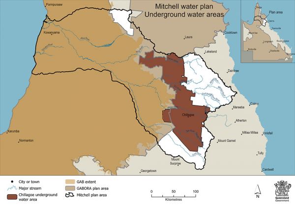
Groundwater
Groundwater (also called underground water) is the water beneath the earth's surface that occurs in pore spaces and fractures of rock formations called aquifers.
In some parts of the Mitchell, groundwater is closely connected to surface water. Because of this, we manage them in the same way. This means that any water user drawing from an aquifer that is under or within 1km of a declared river or 200m of a declared creek will require a water licence to take water. This rule does not apply for water used for stock or domestic purposes.
Groundwater is also managed within the Chillagoe groundwater management area where a water licence is required to take water for all purposes other than stock or domestic.
Groundwater can be taken for any purpose if it’s not within a groundwater management area and is not part of a declared watercourse. However, groundwater managed under the GABORA water plan lies under most of the Mitchell plan area.
The map shows that the Chillagoe groundwater management area (indicated in colour) and the GABORA (indicated in brown) lies under most of the Mitchell water plan area.
Also consider…
- Understand more about the water entitlements and their use in the Minister's performance assessment report, 2023 (PDF, 4.1MB).