Public searches for resource authorities
Undermining search
You can find historic mining activity records for a specific area by generating an undermining report on GeoResGlobe.
If you need lot on plan details to generate the report, use the online title search.
Note: our historic records relating to abandoned mines are incomplete and we cannot guarantee the reliability of this information.
Request for resource authorities and grants information
Use the form below to request for information on resource authorities in a specific area. There are 4 ways to search:
1. Local government authority (LGA)
- Shows all resource authorities for the selected LGA.
- Explains the purpose and types of activities allowed for each authority type.
- The report will be emailed to you as a zip file of up to 12MB. If you do not receive the email within 48 hours, contact MyMinesOnline.
2. Lot on plan
- Enter lot on plan details to find resource authorities that have been granted over the land, as well as pending applications.
- You can find the lot on plan of your land on your rates notice, or you can use the online title search.
- To request for a building unit plan which may use multiple units, enter 0 or 00000 in the lot field (not the individual lot number)—refer to the Queensland Geocoder for more information.
3. Resource authority
- Enter the resource authority (e.g. ML 100055) to find resource authorities that have been granted over the land, as well as pending applications.
4. Resource authority public report
- Provides resource authority details such as holder details, contact information, lodgement and grant dates, area descriptions and registered dealings.
- You will need to enter the resource authority type followed by its number (e.g. ML 100055).
- If found, a link to the report will appear on the page immediately (you will not receive an email).
- Read the glossary of terms to help you understand the report.
Resource authorities request form
 One moment please.
View a map of a resource authority
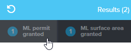
You can view a map showing the location and boundaries of a resource authority using GeoResGlobe.
- Open GeoResGlobe, accept the terms and conditions and click 'Get started'.
- Click 'Search' and click 'All current permits'.
- Enter the resource authority number and press 'Enter' or click the magnifying glass to search.
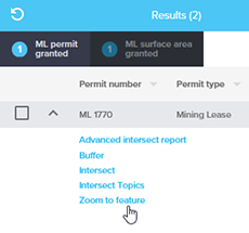
- Tabs will appear with your search results. Click on the required tab.
- Click the down arrow next to your chosen record and click 'Zoom to feature'.
Properties with resource authorities
If you would like to purchase a property with a resource authority, you can find out more about the process, as well as how to view a map showing the resource authorities that might impact the property.