Exploration geochemistry data
The Queensland exploration geochemistry database includes information on surface and drillholes. The data are generated from open file exploration reports submitted by mining companies doing mineral exploration work in Queensland.
Queensland surface and drillhole geochemistry database
This database provides a comprehensive collection of quality digital geoscience data enabling exploration activities to be targeted to prospective mineralised areas in Queensland.
Most of the data has been compiled under agreements between GSQ and external contractors. Additional data is being compiled by a new contract agreement with Map to Mine Pty Ltd that began in June 2014. While data is meticulously compiled and verified from open file company exploration reports, its accuracy is based on the integrity of the original data.
As at June 2014, the Queensland surface and drillhole geochemistry database contains 3,240,079 pieces of geochemical and drillhole data. The user-friendly digital data can be easily retrieved, interrogated, visualised and integrated into a GIS environment for a range of natural resource studies.
Database features
Key features of the database include:
- high-speed interrogation and sub-setting of data
- visualisation through direct integration with, or export to, industry standard GIS and exploration packages (e.g. MapInfo, Arcview, Interdex, Discover, Micromine, Surpac and generic ASCII)
- direct exporting to spreadsheets and word processing programs
- standardised geological codes (based on those used by Geoscience Australia) and
authority tables - ODBC compatible databases can be used as a back-end to the system.
Data coverage
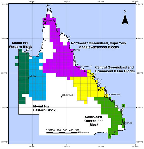
Data in the Queensland surface and drillhole geochemistry database has been packaged into the following data blocks for distribution:
- South East Queensland (SEQ)
- Central Queensland and Drummond Basin (CQ_DB)
- North East Queensland, Cape York and Ravenswood (NEQ_RB_CY)
- Eastern Mount Isa (MIE)
- Western Mount Isa (MIW)
Here is an image of data blocks in the Queensland surface and drillhole geochemistry database.
Number of data pieces for each block (as at June 2014)
| Blocks | Drillhole Location | Drillhole Sample | Drillhole Geology | Rock Chip |
|---|---|---|---|---|
| SEQ | 2,574 | 37,300 | 12,496 | 20,993 |
| CQ_DB | 8,958 | 124,294 | 50,378 | 43,993 |
| NEQ_RB_CY | 25,633 | 459,865 | 205,060 | 86,000 |
| MIE | 43,702 | 201,129 | 134,436 | 59,642 |
| MIW | 29,157 | 121,956 | 51,797 | 35,819 |
| TOTAL | 110,024 | 944,544 | 454,167 | 246,447 |
| Blocks | Stream Sedim's | Soils | Whole rock | Block Total |
|---|---|---|---|---|
| SEQ | 76,539 | 70,720 | 113 | 220,735 |
| CQ_DB | 85,474 | 123,785 | 2,982 | 439,864 |
| NEQ_RB_CY | 201,664 | 326,042 | 3,081 | 1,307,345 |
| MIE | 122,560 | 226,892 | 316 | 788,677 |
| MIW | 78,869 | 161,754 | 4,106 | 483,458 |
| TOTAL | 565,106 | 909,193 | 10,598 | 3,240,079 |
Type of data available
Data is provided on:
- tenure, sample and location—including prospect, company, sample type, sample number and location references
- lithologic and field information—including sampling methodology, lithology, alteration and mineralisation observations
- laboratory methodologies and assay information—including tabulated analytical methodologies, multi-element assays, assay job numbers and data sources
- drillholes—this may include core details, regolith, bulk density, water flow, geophysics, and collar and survey data.
Datum
The geodetic datum for the data is AGD66. The data supplied contains both grid coordinates in metres (easting and northing) and geographical coordinates in decimal degrees (latitude and longitude).
How to get the data
You can order a DVD with statewide digital geochemical data from us or you can download the data from the GSQ Open Data Portal.
(A data management program, Explorer 3, is distributed with the data. It is read-only with reporting and export options, but does not allow edits, deletions or additions. Inaccessible query functions in the cut-down version of Explorer 3 are greyed out. Explorer 3 is written in Visual Basic using a comprehensive data structure for Microsoft Access, SQL Server, Oracle and other ODBC compatible databases. The database also contains ASCII and MapInfo table formats.)