Survey marks and property boundaries
Permanent survey marks are important reference marks, so you must not disturb, destroy or remove them. Find out more below.
Property boundaries
In Queensland, property boundaries are defined by the survey marks (usually white pegs) placed at the boundary corners. They are not defined by GPS points or coordinates. Surveys that define the boundaries are called cadastral surveys, and these include surveys that change or create boundaries (subdivision surveys) and surveys that mark existing boundaries (identification surveys). Only surveyors who are properly registered with the Surveyors Board of Queensland (SBQ) can undertake cadastral surveys.
If your land has not been surveyed recently and the pegs are not in place, you may need to engage a registered cadastral surveyor to have your boundaries professionally re-marked. Defining boundaries can be complex and a surveyor must consider all legal and physical evidence to perform a fair and lawful survey. The surveyor will prepare a plan and submit it to the Queensland Government as an official record of the survey. Note that the survey plan will not show the location of the kerb in relation to the boundaries, so you cannot find your property boundary by measuring from the kerb. If you need information about an easement on your property, you can purchase the relevant easement documents and registered survey plans or consult a registered surveyor. For more information about surveys of property boundaries, see the guidelines issued by the Surveyors Board of Queensland (PDF, 75KB).
Boundary disputes
If you disagree with a surveyor's placement of a corner mark, discuss your concerns with the surveyor. If you believe an error has been made or if you believe there is evidence of negligence, you should seek independent legal advice. Adjoining owners may engage an independent registered cadastral surveyor to identify the exact location of the boundary.
Disputes between neighbours or other property owners need to be settled via dispute resolution, mediation or other remedies available to both parties. For information or advice on boundary disputes, contact the Queensland Civil and Administrative Tribunal.
Fences
To determine if a fence is built along the common boundary, engage a registered cadastral surveyor to carry out an identification survey. If the matter relates to a dividing fence, see the Neighbourhood Disputes (Dividing Fences and Trees) Act 2011 on the Queensland Legislation website.
Retaining walls
To help resolve disputes involving retaining walls, a cadastral surveyor can determine the location of the wall in relation to the boundary, but you should also consider factors such as who built the wall and who benefits from the wall. If the owners of the land cannot settle the dispute, it is recommended that you seek the advice of a legal practitioner and a registered cadastral surveyor experienced in these matters. Visit the Queensland Law Society website to locate a solicitor with experience in this area of law.
Notification of improvements on, near or over the boundary
Surveyors are required to notify all landholders that may be affected by the reinstatement of a boundary. A notification is a written record to advise only, and not a letter of demand to rectify any stated encroachments.
Surveyor entering a property
Surveyors are permitted to enter land in order to carry out surveys and/or place survey marks. Section 22 of the Survey and Mapping Infrastructure Act 2003 provides for that power, subject to section 23 – Surveyor's notice of entry.
Normally a surveyor will approach the occupier beforehand and ask for access directly.
If after making a reasonable attempt to:
- identify himself or herself to a person present at the place who is an occupier of the place
- tell the person
- the purpose of the proposed entry
- and
- that the surveyor is permitted under this Act to enter for the purpose.
The surveyor may, without the occupier's consent:
- enter land around premises at the place to an extent that is reasonable to contact the occupier
- or
- enter part of the place the surveyor reasonably considers members of the public ordinarily are allowed to enter when they wish to contact the occupier.
Under section 27(2)(a) of the Survey and Mapping Infrastructure Act 2003, it is an offence to obstruct the surveyor in the exercise of the power to enter places, unless the person has a reasonable excuse.
Power of entry does not entitle a surveyor to enter a building or other structure where a person resides.
A surveyor must immediately repair or give notice if the property is damaged as a result of exercising the surveyor's power to enter places.
Survey marks
Survey infrastructure is made up of individual survey marks across the state—physical markers on or in the ground indicating land height, positions and boundaries.
Survey marks provide important information to the community as they are used for surveying property boundaries, road building, construction activity, mapping, and other land surveys.
Permanent survey marks
Permanent survey marks are substantial marks such as a concrete block buried 300mm deep with a brass plaque in the centre, or a mini mark in the kerb.
These marks are important for all types of surveying projects, including housing developments, new road and bridge construction, improving railways and environmental mapping.
They usually have a numeric identifier and are registered in the Department of Natural Resources and Mines, Manufacturing and Regional and Rural Development's Survey Control Database (SCDB).
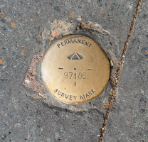
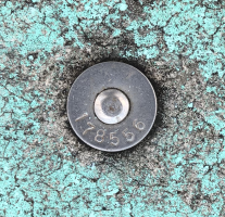
Brass plaque (left), mini mark in kerb (right)
Cadastral survey marks
Cadastral marks are used to mark property boundaries. They are most commonly seen as a white peg.
The peg often has a reference mark, usually an iron pin buried nearby or a nail in the kerb, to help re-establish the corner in the future.
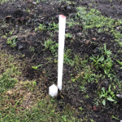
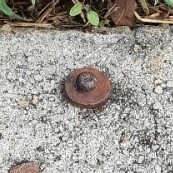
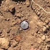
Peg and finder stake (left), nail in kerb (middle), buried iron pin (right)
Interference with survey marks
Permanent survey marks and cadastral survey marks are important reference marks that should not be disturbed. Under section 42 of the Survey and Mapping Infrastructure Act 2003 it is an offence to interfere with a survey mark without approval. Removing, disturbing or destroying survey marks is costly to the community. For example, it can affect construction projects that depend on accurate positioning and height information and lead to increased costs to landholders when they need to get their boundaries resurveyed.
Survey marks are commonly disturbed by:
- construction or development work
- footpath and driveway upgrades
- utilities and services work
- restoration of kerb and channel
- vegetation clearing
- landscaping
- road construction.
If you are conducting this type of work, take care not to interfere with survey marks.
Before starting construction works, consider engaging a registered cadastral surveyor to carry out a search of the construction area. This will show whether there is the potential to interfere with survey marks.
If you notice a survey mark that presents a trip hazard, send an email to GeodeticSupport@nrmmrrd.qld.gov.au with a photo of the survey mark and location details. The relevant authority will follow up with an investigation.
Permanent survey marks
Permanent survey marks are important infrastructure and can only be interfered with or removed after written approval from the Department of Natural Resources and Mines, Manufacturing and Regional and Rural Development.
If a project you are undertaking is likely to interfere with a permanent survey mark, email GeodeticSupport@nrmmrrd.qld.gov.au with details of the mark(s) and the project.
An assessment will be made to determine the impact of the interference on the state geodetic control network and if any survey work is required before the mark(s) are disturbed.
Cadastral survey marks
Cadastral survey marks should only be interfered with or removed if required for the construction of a fence or structure along a boundary, or by a registered surveyor undertaking a survey.
If a project you are undertaking is likely to interfere with a cadastral survey mark, please contact a registered cadastral surveyor for advice on how to proceed. A cadastral search of the area and/or a cadastral survey may be required to be carried out.
For additional information on the removal of survey pegs please refer to the Surveyors Board of Queensland’s information sheet.
If you have a query on the interference of a survey mark, email SurveyAdvice@nrmmrrd.qld.gov.au with details of the mark and the interference.
Accessing survey control information
Queensland Globe
The Queensland Globe is an online interactive tool that turns physical, geographic and spatial government data about a particular location into map format.
Use the Queensland Globe to access hundreds of spatial data layers on Queensland roads, property and land parcels, topography, mining and exploration, land valuations, natural resources (vegetation, water, soil etc.) and more.
The Globe can help you:
- use 2D or 3D views to create a rich interactive experience
- access spatial data anywhere and anytime through your computer, tablet or smartphone web browser
- pinpoint your location and access data when in the field
- browse through historic imagery for a particular area
- compare current and historical data across the state to explore changes over time.
The best place to start is with the video tutorial Getting started with Queensland Globe.
The Queensland Globe is not the point of truth for parcel boundary information and should not be relied on as a source for factual information regarding property boundaries. Keep in mind that the boundaries depicted on the map do not represent the true property boundaries on the ground.
Under the Queensland Government's open data initiative, we have published survey control information through the Location category globe in the Queensland Globe. Survey control reports of marks are free and include the permanent survey mark plan. Read the information about the survey control functions when you are in the globe.
Survey Control Register
If you know the number of a permanent mark, it is possible to access the Survey Control Report (with sketch) directly from any standard web browser, including on mobile devices. The Survey Control Report URL needs to contain the 6-digit permanent mark number, including any leading zeros. For example, for PM number 1234 the URL format will be 'http://qspatial.information.qld.gov.au/SurveyReport/SCR001234.pdf'. View the actual report for this example (PDF, 71KB).
The Survey Control Register file on QSpatial contains all data from current records of the SCDB, as well as ellipsoidal heights and positional uncertainties where available. This data is available for free bulk download.
SCDB can be accessed from most of our business centres. A range of reports are available. Contact us for more information.
Copies of original survey field records can be obtained from the SCDB manager. Email CadastralAdminDataHelp@nrmmrrd.qld.gov.au.
Submitting survey mark information
New permanent survey marks
Details of new permanent marks must be provided to the Department of Natural Resources and Mines, Manufacturing and Regional and Rural Development on Form 6 – Permanent survey mark plan v6.5 (XLSX, 351KB).
For information on how to prepare and lodge permanent survey mark plans, read the completion of permanent survey mark plans (PDF, 492KB).
Maintenance of permanent survey marks
Email CadastralAdminDataHelp@nrmmrrd.qld.gov.au with any updates to existing permanent marks or information about any irregularities observed in the field.
A mark maintenance worksheet is incorporated into the permanent survey mark plan form.
Submitting Global Navigation Satellite System (GNSS) data
Control surveys must comply with the Intergovernmental Committee on Surveying and Mapping (ICSM) standards and practices for control surveys.
For a permanent survey mark to be recognised as a horizontal datum mark in the SCDB, it must be included in the Queensland State Adjustment (known as ANJ). ANJ is an amalgamation of measurements/adjustments from the hierarchy of datum.
For information on how to lodge permanent GNSS data, read:
- Submitting GNSS data for inclusion into the statewide datum adjustment network (PDF, 667KB)
- GNSS static booking form (PDF, 679KB).
Sourcing survey marks, lids and other surveying supplies
Mini marks
A mini mark uses a spike with a pre-drilled hole, which is useful for fitting the prism pole point into the mushroom top. Use the term ‘kerbmarkers’ in online searches to find suppliers.
Mini marks can be used as permanent survey marks (PSMs) in urban areas, provided the mark location and stability conform with the Cadastral Survey Requirements (CSR) section 3.28.2 criteria. They are not suitable for shallow structures, such as kerbing or footpaths, where they may be disturbed or destroyed by vehicles, soil movement or tree roots.
Bolts
Bolts—stainless steel, mushroom-head strike anchors—are increasingly being used as reference marks, with or without washers. You can source them from your local fastener specialist. A bolt will last longer if the washer is countersunk into the footpath using a masonry hole saw, cold chisel and araldite.
Brass plaques
Use the term 'brass permanent survey mark' in online searches to find suppliers.
Star picket tags
Source from geological survey suppliers. Use the terms 'pre-numbered stainless dog tags' or 'aluminium tag suppliers' in online searches.
Deep driven mark covers
Source from concrete casters. They will need to use a mould for a round cover to fit on the pipe.