Cumulative Management Area (CMA)
CMAs are declared where impacts from resource development may overlap.
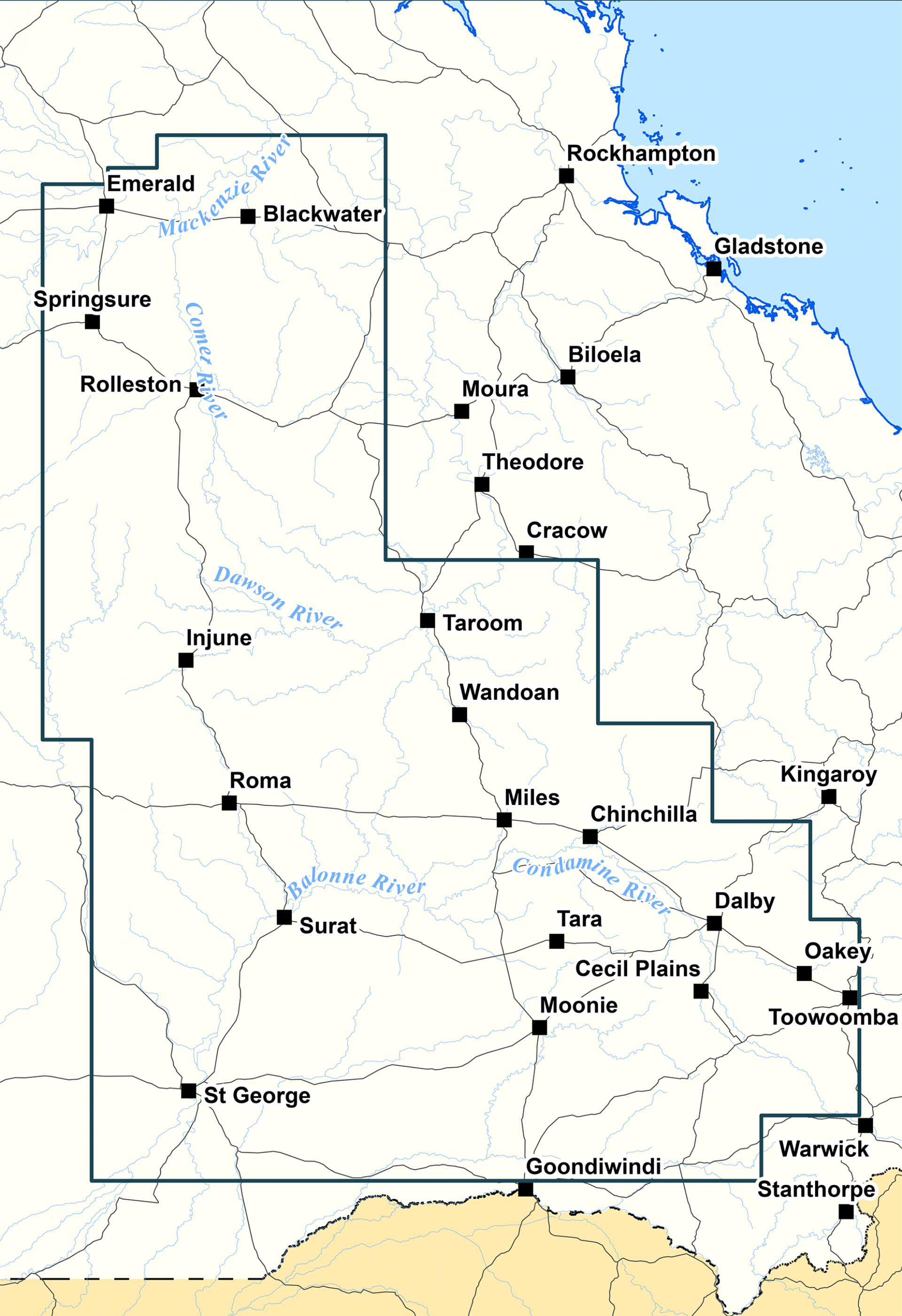
The Surat CMA is the only CMA in Queensland. It was established in 2011 and currently applies to coal seam gas, conventional oil and gas and coal mining tenures. The Surat CMA extends from Toowoomba in the east, to Mitchell in the west, and from Goondiwindi in the south, to north of Blackwater in Central Queensland. The map shows the location of the Surat CMA.
Within a CMA, responsibility for the cumulative assessment and management of impacts is handed over to the independent Office of Groundwater Impact Assessment (OGIA). OGIA sets out its cumulative assessment and management strategies in an Underground Water Impact Report (UWIR) which is updated every three years. The UWIR also includes clear assignment of responsibilities to individual tenure holders for implementing various elements of the management strategies.
Submissions are invited from stakeholders on a consultation draft before OGIA finalises the UWIR. The Department of Environment, Science and Innovation (DESI) is responsible for approving the UWIR and follow-up compliance on its implementation.
This video provides an introduction to the Surat CMA.
Resource activities within the Surat CMA
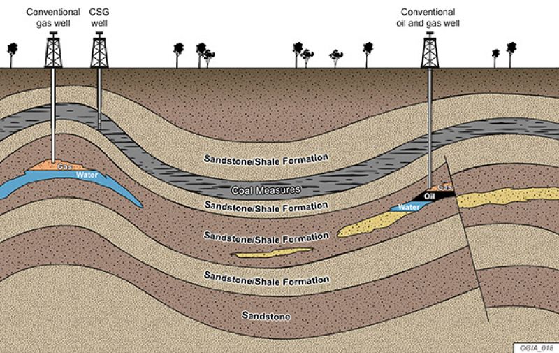
There are three main types of resource activities in the Surat CMA: coal seam gas (CSG), which is also referred overseas as coal bed methane; conventional oil and gas; and coal mining. Generally, the potential groundwater impacts of coal mines and conventional oil and gas extraction are relatively small compared to potential impacts from unconventional extraction.
This diagram illustrates the relative approximate depth and infrastructure of conventional and CSG wells.
Coal seam gas (CSG)
CSG is natural gas that is held within coal formations and trapped underground. CSG is released when the coal formations are depressurised by pumping out groundwater. Read more information about CSG production in Queensland.
Growth in CSG in Queensland has been rapid since 2010 and is now the largest type of resource development in the Surat CMA with tenures covering vast areas of the CMA. CSG wells are generally drilled to a depth of 200 to 800 metres.
There are currently about 9,000 CSG production wells in the Surat CMA between Rolleston in the north, Surat in the southwest and Dalby in the southeast. By 2030 at the peak of development, it is expected that there will be about 22,000 wells.
Conventional petroleum and gas resources
Conventional petroleum and gas resources are oil and gas found typically in sandstone. Conventional petroleum and gas resources are extracted using traditional methods of drilling down through the ‘cap’ rock and allowing petroleum to flow up the well.
Conventional oil and gas extractions in the Surat CMA date back to 1963. They are found on the northern and southern fringes of the CMA. There are fewer than 70 production wells. These wells are drilled much deeper than CSG wells, typically to depths of about 1.5 to 2km below the surface.
Coal mining
Coal mining in the Surat CMA is for the extraction of thermal coal by digging open pits into the coal formations.
Coal is extracted from shallower depths than for CSG, generally less than 100m below the surface.
There are four small open-cut coal mines in the Surat CMA – New Acland (Stages 1 and 2), Cameby Downs, Kogan Creek and Commodore. New Acland mine is expected to begin stage 3 operations once all approvals are finalised. The Wilkie Creek mine closed in 2013. Its new owner may consider reopening the mine in the future. Three additional mines are proposed, near Wandoan.
Groundwater in the Surat CMA
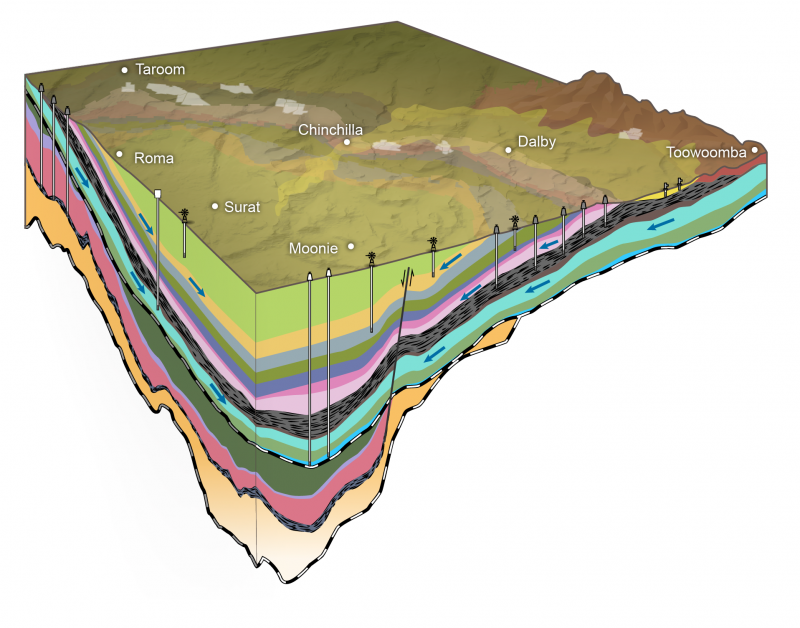
Rock formations in the Surat CMA are mostly alternating layers of consolidated sandstone, clay and siltstone, with bands of coal (coal formations) within some of the layers. These types of formations are called sedimentary formations.
Sedimentary formations within the Surat CMA are grouped into three overlapping basins:
- The Surat Basin contains the coal formation (called the Walloon Coal Measures) from which most CSG and coal is extracted.
- The Clarence-Moreton Basin is the eastern extension of the Surat Basin.
- The Bowen Basin is older and most of it is below the Surat Basin. It is the source of conventional oil and gas, as well as some CSG.
The diagram provides a 3D representation of the main groundwater systems and geology in the Surat CMA.
The sandstone-dominated layers in these three basins are an important source of groundwater used for livestock, agriculture and domestic use, including town water supplies. These aquifers of the Surat and Clarence-Moreton basins are part of the Great Artesian Basin (GAB).
There are approximately 8,000 water supply bores in the Surat CMA within or near to the CSG and coal mining development areas. About 4,000 of these bores access 20,000 megalitres of groundwater per year from the GAB.
The Condamine Alluvium is the other major source of groundwater supply for irrigation purposes in the Surat CMA, sustaining intensive cropping activity. It is a floodplain deposit of sand, silt and clay that sits on top of the Surat Basin, generally less than 80m deep.
Underground Water Impact Reports (UWIR)
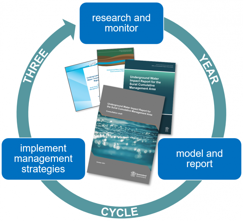
A UWIR is a statutory report prepared by OGIA every three years for the Surat CMA. The report provides:
- Assessment of groundwater impacts laying out the effect on groundwater from existing and proposed CSG, conventional oil and gas and coal mining development. It includes information about groundwater aquifers and research on how they interact with each other (i.e. connectivity). Impacts are predicted with a groundwater flow model. It also helps to identify water bores that may be affected by resource development in the short and long term.
- Proactive strategies for managing impacts such as the proactive make good of water bores ahead of predicted impacts, a monitoring strategy and impact mitigation strategies for affected springs and connected watercourses.
- Assignment of responsibilities to individual tenure holders to implement strategies and for ongoing reporting.
The assessment is completed every three years, as illustrated in the diagram, to consider new scientific research, monitoring and changes in the industry’s development plans. A draft UWIR is prepared and released for public consultation by OGIA, before being finalised and submitted to the Department of Environment, Science and Innovation (DESI) for approval.
An annual review provides updates on the implementation of the UWIR management strategies and discusses any changes to circumstances that could affect the predictions made in the UWIR – for example, changes to resource tenure holders’ development plans.
The UWIR 2021 (PDF, 16.9MB) was approved by DESI and took effect on 1 May 2022. It supersedes previous UWIRs from 2012, 2016 and 2019.
The most recent annual review (PDF, 1.3MB) in 2023 did not identify any new material changes to the impacts predicted in the UWIR 2021.
OGIA liaises with tenure holders and the regulator (DESI) to enable implementation of the UWIR.
Tenure holders are responsible for implementing specific actions in the UWIR, including:
- undertaking baseline assessments
- preparing baseline assessment plans
- implementing make good agreements with water bore owners
- implementing both the water monitoring strategy and the spring impact management strategy.
Find out more about the underground water management framework.
Last updated: 31 Oct 2023